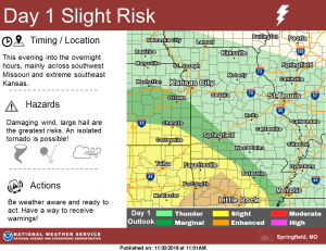
Strong to severe storms are possible in the Ozarks Friday evening, with the best chance for 60 mile per hour winds, quarter size hail, and an isolated tornado south of Springfield.
The Springfield metro area is now under a “marginal risk for severe weather from late this evening into the overnight hours, while areas southwest of Springfield along I-49 and the Missouri-Arkansas border have been upgraded to a “slight risk.”
The National Weather Service says showers and thunderstorms will form along and ahead of a cold front beginning late Friday afternoon.
It appears the brunt of the severe storms will be across northeast Oklahoma and northwest Arkansas.
Get the latest forecast, watches and warnings, and track interactive radar here.